

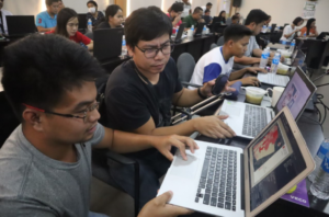
A 𝗕𝗮𝘀𝗶𝗰 𝘁𝗼 𝗜𝗻𝘁𝗲𝗿𝗺𝗲𝗱𝗶𝗮𝘁𝗲 𝗧𝗿𝗮𝗶𝗻𝗶𝗻𝗴 𝗖𝗼𝘂𝗿𝘀𝗲 𝗼𝗻 𝗚𝗲𝗼𝗴𝗿𝗮𝗽𝗵𝗶𝗰 𝗜𝗻𝗳𝗼𝗿𝗺𝗮𝘁𝗶𝗼𝗻 𝗦𝘆𝘀𝘁𝗲𝗺𝘀 (𝗚𝗜𝗦) was held last 𝗔𝗽𝗿𝗶𝗹 𝟮𝟰-𝟮𝟲, 𝟮𝟬𝟮𝟰 at the Don Mariano Marcos Memorial State University - North La Union Campus (DMMMSU-NLUC).
The training course provided fundamental background on Geographic Information System (GIS) principles. It includes spatial data handling procedures such as data encoding, manipulation, storage and presentation. It introduces the concept of GIS-Based approach to analysis, monitoring and evaluation of the environment. It also includes the use of handheld devices and unmanned aerial vehicle (UAV) in geographic data capturing. Finally, the course focuses with applications of GIS in the generation of geographic data and digital and printed maps.
One of the participants shared, “𝘭𝘢𝘩𝘢𝘵 𝘯𝘢𝘮𝘢𝘯 𝘱𝘰 𝘵𝘢𝘺𝘰𝘯𝘨 𝘓𝘎𝘜𝘴 𝘢𝘺 𝘮𝘢𝘺 𝘮𝘢𝘱, 𝘱𝘦𝘳𝘰 𝘩𝘪𝘯𝘥𝘪 𝘶𝘱𝘥𝘢𝘵𝘦𝘥.𝘈𝘯𝘨 𝘩𝘪𝘯𝘥𝘪 𝘶𝘱𝘥𝘢𝘵𝘦𝘥 𝘯𝘢 𝘮𝘢𝘱 𝘩𝘪𝘯𝘥𝘪 𝘦𝘧𝘧𝘦𝘤𝘵𝘪𝘷𝘦. 𝘈𝘯𝘨 𝘯𝘢𝘵𝘶𝘵𝘶𝘵𝘶𝘯𝘢𝘯 𝘱𝘰 𝘯𝘢𝘮𝘪𝘯 𝘴𝘢 𝘵𝘳𝘢𝘪𝘯𝘪𝘯𝘨 𝘯𝘢 𝘪𝘵𝘰 𝘪𝘴 𝘮𝘢𝘱𝘢𝘱𝘢𝘥𝘢𝘭𝘪 𝘶𝘯𝘨 𝘶𝘱𝘥𝘢𝘵𝘪𝘯𝘨 𝘯𝘢𝘮𝘪𝘯 𝘯𝘨 𝘮𝘢𝘱𝘴. 𝘔𝘢𝘨𝘢𝘨𝘢𝘮𝘪𝘵 𝘱𝘰 𝘢𝘯𝘮𝘪𝘯 𝘪𝘵𝘰 𝘴𝘱𝘦𝘤𝘪𝘢𝘭𝘭𝘺 𝘦𝘯𝘷𝘪𝘳𝘰𝘯𝘮𝘦𝘯𝘵, 𝘪𝘯𝘧𝘳𝘢𝘴𝘵𝘳𝘶𝘤𝘵𝘶𝘳𝘦, 𝘣𝘶𝘥𝘨𝘦𝘵 𝘢𝘵 𝘩𝘢𝘻𝘢𝘳𝘥. 𝘕𝘢𝘱𝘢𝘬𝘢𝘭𝘪𝘬𝘪𝘯𝘨 𝘣𝘢𝘨𝘢𝘺 𝘢𝘯𝘨 𝘯𝘢𝘵𝘶𝘵𝘶𝘵𝘯𝘢𝘯 𝘯𝘢𝘮𝘪𝘯 𝘥𝘪𝘵𝘰” (All of the local government units have maps, but they are not updated. The maps that are not updated are not effective. One of the things we learned from this training is, we can update our maps faster. We can use this especially in the environment, infrastructure, budget, and hazards).
Mr. Jomar J. Lucena, resource speaker and faculty at DMMMSU-NLUC, mentioned that GIS can be used in land use planning, environmental monitoring tax mapping, infrastructure and other sectors.
GIS maps provide visual, evidence-based insights for informed decision-making in different sectors, including marine and coastal areas. The GIS maps can be instrumental in mapping and monitoring our marine and coastal areas. It can delineate the extent and conditions of these areas and facilitate better management of Marine Protected Areas. It can also be used as a tool to identify overfished areas, fishing patterns, assess and mitigate coastal hazards such as erosion and storm surges. By using maps and spatial analysis, stakeholders can contribute local knowledge, prioritize conservation actions, and track progress towards shared goals.
---
The Basic to Intermediate Training Course on Geographic Information Systems (GIS) is one of the activities of the "Strengthening Good Governance and Multi-stakeholder Collaboration in FMA 6, Coastal and Marine Areas of the West Philippine Sea” implemented by the Jaime V. Ongpin Foundation Inc. under the INSPIRE Project.
𝗔𝗯𝗼𝘂𝘁 𝘁𝗵𝗲 𝗜𝗡𝗦𝗣𝗜𝗥𝗘 𝗣𝗿𝗼𝗷𝗲𝗰𝘁
Investing in Sustainability and Partnership for Inclusive Growth and Regenerative Ecosystems (INSPIRE) is a five-year grant facility of the United States Agency for International Development (USAID) that aims to improve natural resource resilience and security through the increased participation and engagement of civil society organizations (CSOs), media, academe, and local communities. It envisions to expand civil society participation and influence in natural resource governance for greater accountability and better results and complementation of local conservation and climate change mitigation actions. The Gerry Roxas Foundation (GRF) is the lead implementing partner for INSPIRE.
